Cruising Sailors Forum Archive
I have the printed Tidal Current Atlas for Delaware Bay, pretty sure I bought it at South Jersey Marina back in the 70's... They wouldn't have a clue what you'd be referring to nowadays, of course... It's about a 30 page booklet, with current diagrams for the entire bay and river, for every hourly stage of the tide, similar to the current diagrams of LI Sound and NY Harbor reproduced in ELDRIDGE's.. Couldn't be any simpler, and I've always thought it was kind of fun to plan a passage that way, never fails to remind me of being taught by my dad what a pair of dividers are for... Nowadays, I think many people are terrified of marring the perfect surface of their chart table with the damn things - if they even have a chart table, that is... (grin)
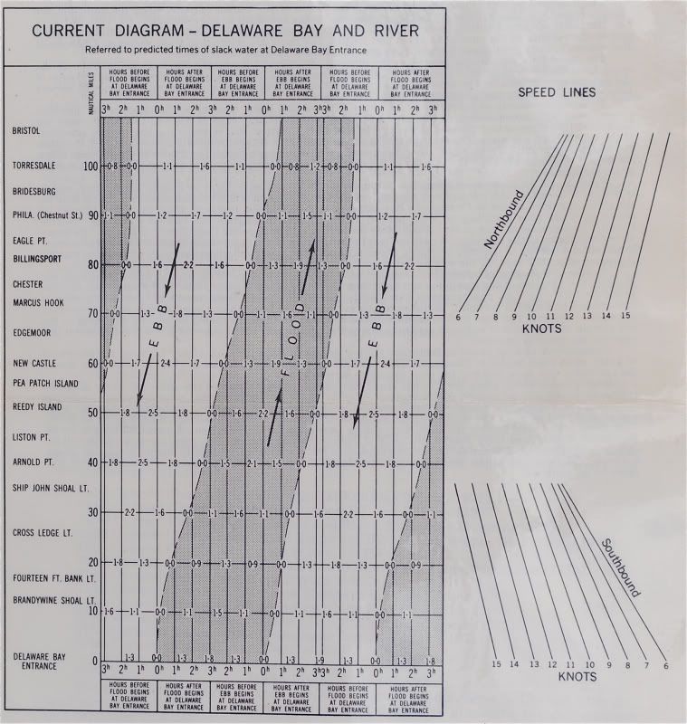
Anyway, back in the Age when dinosaurs still roamed the Earth, the tide books used to include a current diagram using speed lines, like the one pictured below... You simply walk your parallel rules over from your estimated speed line onto the diagram, and choose what looks best to you... It's a complete mystery why these diagrams seem to have disappeared from all publications, but I haven't seen one in probably 20 years... Mine's already been laminated a couple of times over...
Based on an average speed between 6-7 knots, I'd want to be abeam of Brandywine Shoal Light about 1 hour "After Flood Begins at Delaware Bay Entrance"... Being a bit later wouldn't kill you, since as you start picking up a fair current, your estimated speed is gonna spike anyway... Just guessing at what sort of speed you run under power, but you could probably hit Brandywine as late as 3 hours after the flood starts, and still make it to the canal before the current starts ebbing up there...

Messages In This Thread
- Suggestions for Delaware Bay - C&D canal itinerary?

- With W and NW winds in the forecast
- are you suggesting he go north
- Yes and no.
- Larry, the tide "up" the Del Bay strats just after 7:00 AM
- The current turns to ebb (at mid-bay) around 3PM tomorrow, give or take

- I'm not sure what current charts you're looking at...Nobeltec, Navionics (Northstar) and Furuno all say otherwise?
- Funny that NOAA doesn't have downloadable current tables...
- Funny also that the iPhone insists on capitalizing after every CR.

- Try this NOAA site
- What I was looking for was a downloadable table...

- THere are other sources, DDW
- Hmm.... that one is pretty good, but you can only get one location at a time?

- Get a Nobeltec Version (even an older one from Ebay) w/ Tides and Currents
- LMAO! This is a classic example of how this all was SO much simpler 30 years ago... (grin)

- Hmm.... that one is pretty good, but you can only get one location at a time?
- THere are other sources, DDW
- What I was looking for was a downloadable table...
- Funny also that the iPhone insists on capitalizing after every CR.
- DEpends on what current station you look at
- Funny that NOAA doesn't have downloadable current tables...
- I'm not sure what current charts you're looking at...Nobeltec, Navionics (Northstar) and Furuno all say otherwise?
- The current turns to ebb (at mid-bay) around 3PM tomorrow, give or take
- Larry, the tide "up" the Del Bay strats just after 7:00 AM
- Itinerary For Del Bay
- Yes and no.
- are you suggesting he go north
- Either get up early tomorrow morning or...
- the Coast Guard anchorage...
- Summit North Marina on the Canal
- With an early start, tomorrow sounds do-able in your boat...
- Different approach

- Could have been luck, or youth, 3 times through the Deleware have all been surprisingly easy.

- Thanks! Going to stay in Cape May a day or two...
- When at Cape May, I use...
- food for thought
- With W and NW winds in the forecast